Weather models are hinting at an area of low pressure forming near the Bahamas within the late Saturday to early Sunday time frame.

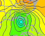
Late Saturday Night
While these models are not correlating with its exact timing of formation, they do show it eventually moving north-northwest. Several models show it staying off the coast of Florida and eventually making landfall near Georgia/South Carolina. Not that the east coast needs anymore rain, but it does show that once it makes landfall, it continues to move northward up into New England.

Tuesday Morning

Wednesday Night
Now, what kind of forecaster would I be if I did not show/tell you the uncertainties? There is an outlying model that shows this low pressure forming in the west of Florida in the Gulf of Mexico. While its formation time is later than the others, this particular model shows it moving northward into Florida and then eventually moving up the east coast.

Unfortunately, we will just have to wait and see what and if anything will happen as we progress into the next upcoming work week.
Question to leave you with: Could both lows form, eventually meet, and then combine into one and move up the east coast?
~Meteorologist Heather Brinkmann
No comments:
Post a Comment