As December 2011 gets ready to come to an end, we had an incredibly mild start to the 2011-2012 winter season. It was almost as if mothernature decided to skip winter and jump right into spring with temperatures well into the 40s for much of the month. Chicago O'Hare airport officially recorded 1.7" of snow this month which is well below the average of 8.3" for the month.
So, the million dollar question asked is........what's in store for 2012? The picture below helps illustrate the overall pattern across the U.S. You can see the jet stream from northern Washington through North Dakota and stretch down through Tennesse and back up across the northeast. Typically with this type of flow, we have clippers systems that move through, however, the warm air from the Pacific is able to push into the midwest helping temperatures stay well above normal.
There are signs of colder air moving into the Midwest to start the new year, but they are short lived. The next couple weeks show the same pattern continuing, but historically speaking, we should finally start seeing snow events, not rain events through Jan and Feb. Only time will tell, so make sure to keep following us on our blog and twitter!
Chicago was well on its way to breaking a record for the latest date with its 1st measurable snowfall. That changed, however, as an Alberta clipper system moved through the area. Anywhere from a trace to 1.0" was recorded across the Chicago metro area and into northern Indiana.
Courtesy of the NWS
With O'Hare recording 0.4" of snow this past event, Chicago ties for the 5th latest date to record measurable snowfall. The record still stands at Dec.16th, 1965. If this past system would have stayed to the south, it's likely that we would have broken this record since the next 7 days appear to show no snow coming up. A strong system could develop and move across the Great Lake region by next Wednesday the 14th, however, this appears to be a rain producer at this time.
With the east coast getting hammered with continuous rain, the last thing they need right now is cold temperatures... Well, unfortunately that is going to be the case today. Not only will they receive bitter cold temperatures, but snow will be an issue today as well.
With the heaviest snow falling in the Appalachians today, areas near at lower elevations still could see snow as well. Accumulations for these lower areas may only be a dusting to an inch at most, but with the current rain, this will make for very slushy conditions.
This system will continue to move northeastward tonight giving parts of New England a chance at receiving snow tomorrow.
The area shaded in lighter blue should see two to four inches of snow, while the darker blue should see three to five inches. This rain should start to switch over to snow in the higher elevations this afternoon and will not end until later tonight.
Temperatures within the rain filled areas looked to get below freezing, so this will definitely be a hazard for icy conditions.
The heavy rain will continue across these eastern states today before moving northeast into New England tomorrow. While this rain moves out this area today, snow will make its way in.
This is the area expecting a decent amount of snowfall for Wednesday. If this low pressure system sets up as expected, significant snowfall will visit the Appalachian Mountains Wednesday into Thursday.
NOAA
The current HPC Winter Weather Forecast expects four to eight inches across the outlined areas tomorrow.
Once this system moves out on Wednesday, much cooler and drier weather will settle into the area. Say goodbye to those 70s, because the 30s and 40s are moving in!
The U.S. is quite quiet today, but this is what we are currently monitoring. This is the same set of snow that was
seen in Texas and Oklahoma yesterday. There is some embedded bands of heavier
snow within this. West Burlington, IA just reported an inch of snow. All in
all, it is starting to weaken and will do so as it makes its way northeast
throughout the morning. I expect this to turn to more of a lighter snow/rain
as it reaches our area and as the sun starts to heat us up.
Sticking to our area, northeast IL will have some scattered
lake effect flurries throughout the day today. I only expect a dusting at most.
A strong early season system dumped nearly a foot of snow in a few locations across Indiana on Tuesday evening. Impressive satellite imagery showed a tight low pressure system drop snow from as far south as Mississippi to as far north as Michigan. The highest amount of 10" was recorded in Peru, Indiana. Snow rates were close to 2" per hour at times. The pictures below show the total snow cover as well as the cumulative snowfall across Indiana
Picture courtesy of the NWS
Picture courtesy of the NWS
As we look ahead, there is a good chance more snow is likely across the plains later this weekend. Where the rain/snow line sets up is always difficult, especially this time of year. IA, IL, NE, and WI all have the chance of seeing some accumulating snow this weekend. Stay tuned!
Mark it down! Flurries fell at the Cherry Logistics' Weather Center for the first time this snow season.
With a chance of snow flurries present in our forecast today, the radar proves our forecast correct. But one thing that the our meteorologists did not forecast was graupel.
This is a view from the front of our office today. As swath of precipitation came towards us, little white pellets began falling from the sky. Someone asked, "Is it hailing outside?" While graupel may look like hail, they are actually two different types of precipitation.
Hail is precipitation in the form of lumps of ice. Hail is produced in cumulonimbus clouds. They hail balls grow within the thunderstorm and add a layer of precipitation onto it when moved around in that cloud. Once the hailstone becomes too heavy, the hail then falls to the ground.
Graupel is made by a riming process as they these snow crystals pass through clouds with supercooled water. When this supercooled water comes in contact with the crystals, they form graupel. Graupel is usually 2-5 mm and is known to fall when it 0° Celsius.
And just as much as they are called snow pellets, they hurt just like pellets too!
If you are a tornado enthusiast like myself, you will probably not even read the rest of the blog post but instead watch the video over and over again.
The Storm Prediction Center put out a severe weather outlook for yesterday's severe weather. They were forecasting that severe storms would occur in the area shaded in yellow.
This next map shows the probability of one inch or greater hail falling. The hatching indicates two inch or greater hail.
This map shows the probability of tornadoes occurring. This hatching indicates the probability of an EF2-EF5 tornado occurring within the designated area. Now in my years chasing, it is very rare that the Storm Prediction Center denotes hatching on a certain area of the map within close proximity to the time of storm initiation. Weather nerds, like myself, get very excited for this because this shows that the Storm Prediction Center is very confident with their forecast of a strong tornado.
Even though snow was to be forecasted at my desk yesterday, I could not help but to get excited about forecasting these tornadoes. There were signs of a severe weather outbreak since last weeks model runs. It was like the feeling of Christmas morning when you know there are presents under the tree but you do not know for certain of just what is under the wrapping paper... And if we want to go with the theme of Christmas, Mother Nature was sure to fill Santa's role perfectly.
To keep the variables simple for the non-weather folk, there was enough moisture, energy (2500 J/kg), and instability ahead of the front to produce some major storms.
All morning long was a waiting game, but around 1:30 PM, storms started to fire. The area of convection seen on this visible satellite shows the overshooting tops of the thunderstorms. If you look close enough, you can see the agitated cumulus clouds within range of those popping thunderstorms.
About 15 minutes later is when these storms started to appear on radar. Once these storms started to mature, they rapidly moved northeast.
This particular cell was the one to be watched for the rest of the evening. As it crosses the boarder into Oklahoma, a hook was visible on radar and the intensity within the storm started to increase.
As you can see, the cell west of Lawton was not the only storm that was worth watching. Storms continued to fire throughout the rest of the night with tornado warnings lasting until early this morning.
While radar is impressive to some, these photographs of the tornadoes taken by James G. LaDue are much more enjoyable.
James G. LaDue
James G. LaDue
James G. LaDue
As if Oklahoma was not stirred up enough by storms yesterday, a magnitude 3.6 earthquake shook the state last night. This followed the magnitude 4.7 and 5.6 earthquakes that happened Saturday. Not the nicest year for Oklahoma, but the state did set a lot of other weather records as shown by the National Weather Service here.
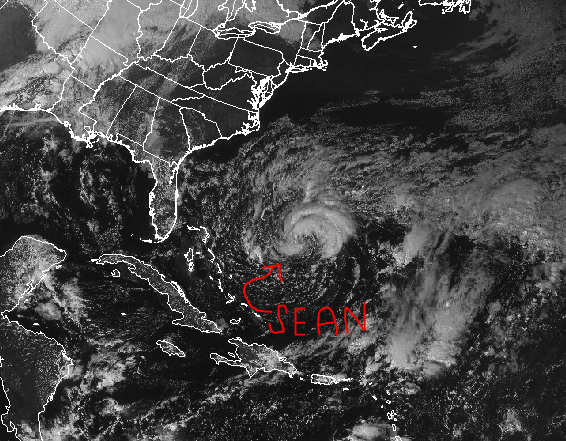
Activity in the Atlantic Ocean has not decided to hibernate for the winter just yet...
Sean reached tropical storm criteria just earlier today. Located about 400 miles southwest of Bermuda, Sean reached maximum sustained winds of 45 miles per hour. While some signs show strengthening, Sean is not expected to reach hurricane criteria.
Tropical Storm Sean will continue to move west before he starts to make a gradual turn to the northwest. As the picture above shows, after he makes the northwest movement, he will fishtail away from the United States.
While Sean will not directly impact the United States, he will generate swells strong enough hit the southeastern U.S. shore.
A dominating high pressure system
will move in today which will give the northwest mostly sunny skies... But it won't last for long.
A low pressure system located just southeast of Alaska is on track to arrive in the contiguous states tomorrow. As a cold front that is associated with this
system passes through, heavier precipitation will coincide along with it.
It would not surprise me if the National
Weather Service issued a snow advisory in the higher elevations as this cold
front passes. As the cold front moves through northwest Washington, colder air
will usher in and lighter snowfall amounts are expected. In northeast Oregon, mountains may see 2-4
inches of snow Wednesday night and into Thursday. With the cities located closer to the
Pacific, Thursday looks to have a chance for some pop up thunderstorms. For higher elevations such as South Lake
Tahoe and northern California, windy conditions will take place Thursday with
snow showers along and behind the cold front. Snow accumulation for this area is
looking to be up to 12 inches at this time and light accumulations possible in
the valley floors.
…. Main message for the northwest U.S.: Be ready for much cooler temperatures to be settled in by the end of the
work week.
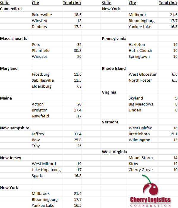
As if the east coast has not gotten enough of a beating these past couple months, Mother Nature was sure to keep it going. What a better way to kick off the snow season than to have recordings of over 30 inches.
Starting Friday and ending yesterday, snow fell from Virginia to Maine. In New York City's case, they had not seen a measurable October snowfall since 1925. Even in the storm of 1925, the snow that was recorded was less than an inch.
Taken From Tom Skilling
No, you are not seeing this map wrong; it does indeed say 28 inches near Northampton, Massachusetts. This is a storm total map that displays values recorded up until this morning.
Here are some other notable snow totals:
Nor'easters (the name for this type of storm) occur between October and April. Winter conditions help these storms to occur regularly but only a few produce damage such as the one that did this weekend. As of 9 AM this morning, 2.1 million power outages had been reported.
Nor'easters get their name from the strong northeasterly winds that blow in from the ocean and ahead of the storm. The severe Nor'easters tend to form off-shore and off the coast of Florida. The Gulf Stream warms and generates a low pressure center. As it makes its way up the east coast, it gathers warm and moist air from the Atlantic. The difference in temperature from the warm water to the cold air over land is what causes the Nor'easter to become intense and produce heavy precipitation. Along with heavy rain and snow, Nor'easters can bring winds greater than 60 miles per hour.
NOAA: 4/16/07
It may have been the northeast United States that received a ton of snow this past weekend, but it looks like the northwest will have its chance later this week.
So how did last night unfold in Texas? For those wondering, snow did indeed impact parts of the Texas Panhandle last night. Below are a few snow totals:
While these amounts are impressive, the snow did not stick to the pavement, but grassy surfaces instead. With high temperatures expected to push close to 60 degrees tomorrow, snow will likely be completely gone before the weekend begins. Below a few current traffic cams show the current conditions as of 3PM CST.
For those of you living in Jamestown, Rochester, and Buffalo New York look out! You will likely see your 1st snow flakes since mid-April later this evening. While this may also seem early for Buffalo and Rochester, they are actually right on target for their 1st snow flakes of the season.
An unseasonable blast of cold air will be shooting out of Colorado this afternoon and reaching Texas by later this evening. As rain showers develop, there will likely be a switchover to some light snow across the Panhandle region. Far western Oklahoma (Boise City) and Dalhart, Texas will likely see some accumulating snow by Thursday morning. The question many of you may be asking is.....when was the earliest measureable snowfall across the Panhandle?
The earliest measurable snowfall for Amarillo occurred on September 29th 1984 when 0.3" of snow was recorded. Heavier amounts of 2" was seen near Stratford, Texas.
So the question remains.....will the snow stick to the pavement later tonight? Based on ground temperatures, it is highly doubtful, however, wouldn't be surprised to see snow on the grass.
So first was California......now Texas, but which area will be next to see snow? The east coast perhaps? Check out our blog tomorrow for more details!
What was Tropical Storm Rina just this morning is now Hurricane Rina this afternoon. Reports this afternoon from a Hurricane Hunter aircraft found that Rina was rapidly intensifying. Hurricane models are already forecasting her to be a category-2 hurricane by tomorrow and a category-3 by tomorrow night.
Hurricane Rina is currently about 200 miles southwest of Grand Cayman. Her maximum sustained winds have just increased to 75 miles per hour, and she continues to track northwest at 5 miles per hour. Some models show her traveling through western Cuba and towards the Florida coast.
To some, it seems a little late in the year to be getting hurricanes, but actually, the Atlantic hurricane season runs from June 1st to November 30th.
NOAA shows in this graph that the number of hurricanes and tropical storms per 100 years' peak runs from mid August to late October. From 2001 to 2010, 17 hurricanes have been recorded in October.
And just as climatology shows, Hurricane Rina has originated right in the area she should, the Caribbean Sea.
How was scraping the frost off of your car this morning? I know I was not too happy to have to get out my scraper as I shivered doing so. Low temperatures this morning fell well into the 30s and at the Aurora Airport, 28 degrees was recorded.
It is hard to want to think about this past week's weather because of the beautiful sunshine we are experiencing today, but these past several days have given us the coldest temperatures we have felt all season. Grumbles of "I hate this weather," or "It's way too cold out," or even "This is the worst weather ever" arose during the past couple days.
But to those people complaining, I ask you this, is thisthe worst weather ever?
Remember back to these series of radar images...
This may not have been the coldest temperatures you have experienced, but for some, it was the most precipitation they have ever seen. Snowmageddon, the Snowpocalypse, or whatever you want to name the February 2011 blizzard recorded the third heaviest snowfall since 1886.
NCDC
This image shows the snowfall accumulations from the central to the northeast United States. From 6 AM on January 31st through 9 PM on February 2nd, these Illinois sites were selected by the Hydrometeorological Prediction Center for their total snowfall:
Antioch 27.0"
Glen Ellyn 24.3"
St. Charles 22.7"
Beach Park 21.7"
Geneva 21.5"
With La Niña in place for this fall, winter, and spring, it is very possible that we will see and exceed our five year snow average at O'Hare Airport of 52.1 inches.
So even though we do not have snow on the ground yet, make light of these past couple days of "the worst weather ever." Because as sad as it is, the worst part about this Autumn cold, cloudy, and windy weather is knowing that this is about as good as it is going to get for the next six months.
Well, if you have not already seen footage of the massive dust storm that occurred in Texas yesterday, here is a great video that shows just what it is like to be in the path of a haboob.
"Ha-WHAT?!" is the exact statement I heard from a fellow employee this morning, and I am sure he is not the first to ask this. A haboob is an Arabic term for an intense dust storm or strong wind. Haboobs are observed throughout the extremely dry regions of the world. Most haboobs are created from the collapse of a thunderstorm but some are associated with cold fronts.
NWS Lubbock, TX
NWS Lubbock, TX (click to animate)
Yesterday, in Lubbock's case, the haboob was created from a strong cold front that pushed through Texas. As we know and have seen in the news, Texas has been extremely dry and hot all summer. When strong cold fronts such as the one in Texas move through, they tend to push that hot and dry air out. When this happens, dust is lifted from the ground and is carried with the strong winds that are created from this front. This, in turn, creates a haboob.
This may be hard to visualize since there are so many weather terms, so think of it this way; If you have ever been to the ocean, you will notice that waves come crashing into the coast. When you look closely, you will see that as those waves come closer to the coast, sand/sediment is picked up from the bottom and moved forward with those waves onto the shore. This is the same occurrence for dust storms. Just think of the waves as as the dust storms and and the sand/sediment as dust.
Ocean vs. Haboob
Winds topped out at 75 miles per hour with this storm. The National Weather Service in Lubbock received many reports of structure damage, power outages, and even wildfires set from these strong winds.
NWS Lubbock, TX via Emily Davenport
Much of southern Texas is currently under a Red Flag Warning. This means that extreme fire weather conditions are either occurring now or will soon. The combination of dry conditions, low humidity, and strong winds create these fire weather conditions.