Here are pictures of the differences in what the weather models are showing for 7 AM on Saturday:

GFS

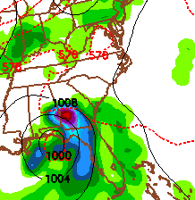
NAM
As you can see, the NAM model shows more of a defined formation than the GFS. The NAM is suggesting that this storm will stay coastal and move north into Louisiana. The GFS is showing that it will move northeast and track into the eastern states.
Here is what the GFS is showing for its track into the eastern states:
Sunday 1 PM

Monday 7 AM

Monday 1 PM

Tuesday 1 PM
Now, this is just what one model is showing. Keep in mind that these models cannot come together on a definite track for this possible tropical storm, so we will just have to wait and see how Friday pans out. If this storm forms as the NAM is showing, I will be sure to give you live updates from New Orleans.
-Meteorologist Heather Brinkmann


