A strong early season system dumped nearly a foot of snow in a few locations across Indiana on Tuesday evening. Impressive satellite imagery showed a tight low pressure system drop snow from as far south as Mississippi to as far north as Michigan. The highest amount of 10" was recorded in Peru, Indiana. Snow rates were close to 2" per hour at times. The pictures below show the total snow cover as well as the cumulative snowfall across Indiana
Picture courtesy of the NWS
Picture courtesy of the NWS
As we look ahead, there is a good chance more snow is likely across the plains later this weekend. Where the rain/snow line sets up is always difficult, especially this time of year. IA, IL, NE, and WI all have the chance of seeing some accumulating snow this weekend. Stay tuned!
Mark it down! Flurries fell at the Cherry Logistics' Weather Center for the first time this snow season.
With a chance of snow flurries present in our forecast today, the radar proves our forecast correct. But one thing that the our meteorologists did not forecast was graupel.
This is a view from the front of our office today. As swath of precipitation came towards us, little white pellets began falling from the sky. Someone asked, "Is it hailing outside?" While graupel may look like hail, they are actually two different types of precipitation.
Hail is precipitation in the form of lumps of ice. Hail is produced in cumulonimbus clouds. They hail balls grow within the thunderstorm and add a layer of precipitation onto it when moved around in that cloud. Once the hailstone becomes too heavy, the hail then falls to the ground.
Graupel is made by a riming process as they these snow crystals pass through clouds with supercooled water. When this supercooled water comes in contact with the crystals, they form graupel. Graupel is usually 2-5 mm and is known to fall when it 0° Celsius.
And just as much as they are called snow pellets, they hurt just like pellets too!
If you are a tornado enthusiast like myself, you will probably not even read the rest of the blog post but instead watch the video over and over again.
The Storm Prediction Center put out a severe weather outlook for yesterday's severe weather. They were forecasting that severe storms would occur in the area shaded in yellow.
This next map shows the probability of one inch or greater hail falling. The hatching indicates two inch or greater hail.
This map shows the probability of tornadoes occurring. This hatching indicates the probability of an EF2-EF5 tornado occurring within the designated area. Now in my years chasing, it is very rare that the Storm Prediction Center denotes hatching on a certain area of the map within close proximity to the time of storm initiation. Weather nerds, like myself, get very excited for this because this shows that the Storm Prediction Center is very confident with their forecast of a strong tornado.
Even though snow was to be forecasted at my desk yesterday, I could not help but to get excited about forecasting these tornadoes. There were signs of a severe weather outbreak since last weeks model runs. It was like the feeling of Christmas morning when you know there are presents under the tree but you do not know for certain of just what is under the wrapping paper... And if we want to go with the theme of Christmas, Mother Nature was sure to fill Santa's role perfectly.
To keep the variables simple for the non-weather folk, there was enough moisture, energy (2500 J/kg), and instability ahead of the front to produce some major storms.
All morning long was a waiting game, but around 1:30 PM, storms started to fire. The area of convection seen on this visible satellite shows the overshooting tops of the thunderstorms. If you look close enough, you can see the agitated cumulus clouds within range of those popping thunderstorms.
About 15 minutes later is when these storms started to appear on radar. Once these storms started to mature, they rapidly moved northeast.
This particular cell was the one to be watched for the rest of the evening. As it crosses the boarder into Oklahoma, a hook was visible on radar and the intensity within the storm started to increase.
As you can see, the cell west of Lawton was not the only storm that was worth watching. Storms continued to fire throughout the rest of the night with tornado warnings lasting until early this morning.
While radar is impressive to some, these photographs of the tornadoes taken by James G. LaDue are much more enjoyable.
James G. LaDue
James G. LaDue
James G. LaDue
As if Oklahoma was not stirred up enough by storms yesterday, a magnitude 3.6 earthquake shook the state last night. This followed the magnitude 4.7 and 5.6 earthquakes that happened Saturday. Not the nicest year for Oklahoma, but the state did set a lot of other weather records as shown by the National Weather Service here.
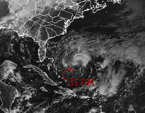
Activity in the Atlantic Ocean has not decided to hibernate for the winter just yet...
Sean reached tropical storm criteria just earlier today. Located about 400 miles southwest of Bermuda, Sean reached maximum sustained winds of 45 miles per hour. While some signs show strengthening, Sean is not expected to reach hurricane criteria.
Tropical Storm Sean will continue to move west before he starts to make a gradual turn to the northwest. As the picture above shows, after he makes the northwest movement, he will fishtail away from the United States.
While Sean will not directly impact the United States, he will generate swells strong enough hit the southeastern U.S. shore.
A dominating high pressure system
will move in today which will give the northwest mostly sunny skies... But it won't last for long.
A low pressure system located just southeast of Alaska is on track to arrive in the contiguous states tomorrow. As a cold front that is associated with this
system passes through, heavier precipitation will coincide along with it.
It would not surprise me if the National
Weather Service issued a snow advisory in the higher elevations as this cold
front passes. As the cold front moves through northwest Washington, colder air
will usher in and lighter snowfall amounts are expected. In northeast Oregon, mountains may see 2-4
inches of snow Wednesday night and into Thursday. With the cities located closer to the
Pacific, Thursday looks to have a chance for some pop up thunderstorms. For higher elevations such as South Lake
Tahoe and northern California, windy conditions will take place Thursday with
snow showers along and behind the cold front. Snow accumulation for this area is
looking to be up to 12 inches at this time and light accumulations possible in
the valley floors.
…. Main message for the northwest U.S.: Be ready for much cooler temperatures to be settled in by the end of the
work week.