Monday, October 31, 2011

'Snowtober'

As if the east coast has not gotten enough of a beating these past couple months, Mother Nature was sure to keep it going. What a better way to kick off the snow season than to have recordings of over 30 inches.

Starting Friday and ending yesterday, snow fell from Virginia to Maine. In New York City's case, they had not seen a measurable October snowfall since 1925. Even in the storm of 1925, the snow that was recorded was less than an inch.

Taken From Tom Skilling


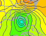
No, you are not seeing this map wrong; it does indeed say 28 inches near Northampton, Massachusetts. This is a storm total map that displays values recorded up until this morning. 


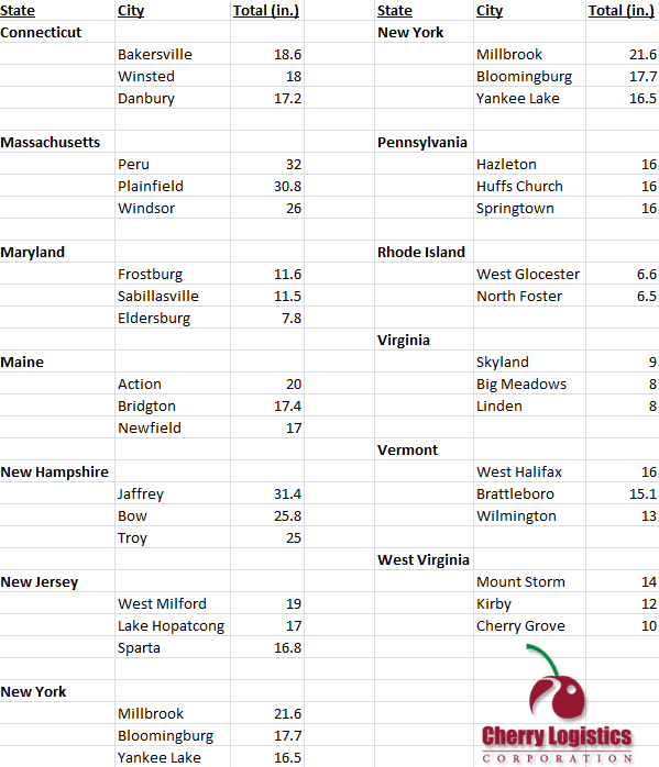
Here are some other notable snow totals:


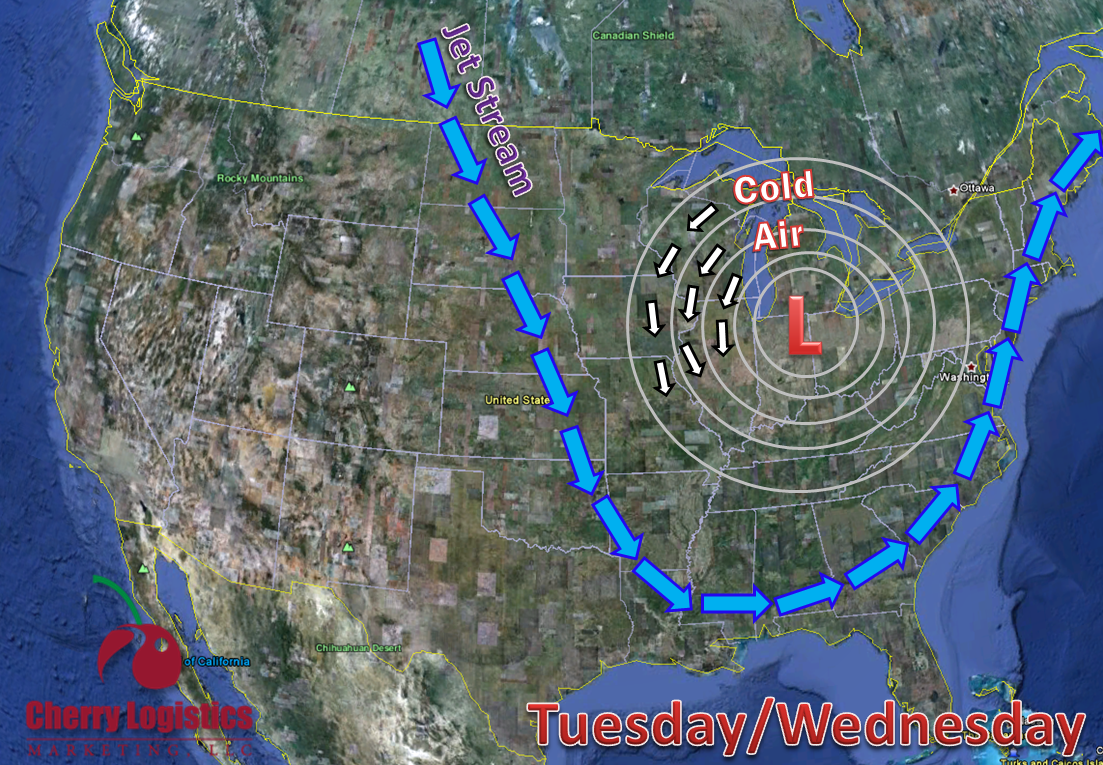
Nor'easters (the name for this type of storm) occur between October and April. Winter conditions help these storms to occur regularly but only a few produce damage such as the one that did this weekend. As of 9 AM this morning, 2.1 million power outages had been reported.

Nor'easters get their name from the strong northeasterly winds that blow in from the ocean and ahead of the storm. The severe Nor'easters tend to form off-shore and off the coast of Florida. The Gulf Stream warms and generates a low pressure center. As it makes its way up the east coast, it gathers warm and moist air from the Atlantic. The difference in temperature from the warm water to the cold air over land is what causes the Nor'easter to become intense and produce heavy precipitation. Along with heavy rain and snow, Nor'easters can bring winds greater than 60 miles per hour. 

NOAA: 4/16/07


It may have been the northeast United States that received a ton of snow this past weekend, but it looks like the northwest will have its chance later this week. 


~Meteorologist Heather Brinkmann

Thursday, October 27, 2011

From Texas to New York

So how did last night unfold in Texas?  For those wondering, snow did indeed impact parts of the Texas Panhandle last night.   Below are a few snow totals:

Amarillo, TX:  3.0"
Vega, TX:       2.0"
Hereford, TX:  1.0"
Boise City, OK: 1.0"

While these amounts are impressive, the snow did not stick to the pavement, but grassy surfaces instead. With high temperatures expected to push close to 60 degrees tomorrow, snow will likely be completely gone before the weekend begins.  Below a few current traffic cams show the current conditions as of 3PM CST.


For those of you living in Jamestown, Rochester, and Buffalo New York look out!   You will likely see your 1st snow flakes since mid-April later this evening. While this may also seem early for Buffalo and Rochester, they are actually right on target for their 1st snow flakes of the season. 

 Courtesy of the NWS in Buffalo, NY


Eric Szos
Chief Meteorologist


Wednesday, October 26, 2011

Texas Snow!!

An unseasonable blast of cold air will be shooting out of Colorado this afternoon and reaching Texas by later this evening.  As rain showers develop, there will likely be a switchover to some light snow across the Panhandle region.  Far western Oklahoma (Boise City) and Dalhart, Texas will likely see some accumulating snow by Thursday morning.   The question many of you may be asking is.....when was the earliest measureable snowfall across the Panhandle?


The earliest measurable snowfall for Amarillo occurred on September 29th 1984 when 0.3" of snow was recorded. Heavier amounts of 2" was seen near Stratford, Texas. 


So the question remains.....will the snow stick to the pavement later tonight?   Based on ground temperatures, it is highly doubtful, however, wouldn't be surprised to see snow on the grass. 

So first was California......now Texas, but which area will be next to see snow?   The east coast perhaps?   Check out our blog tomorrow for more details!


Eric Szos
Chief Meteorologist


Monday, October 24, 2011

6th Hurricane of the Season


What was Tropical Storm Rina just this morning is now Hurricane Rina this afternoon. Reports this afternoon  from a Hurricane Hunter aircraft found that Rina was rapidly intensifying. Hurricane models are already forecasting her to be a category-2 hurricane by tomorrow and a category-3 by tomorrow night.


Hurricane Rina is currently about 200 miles southwest of Grand Cayman. Her maximum sustained winds have just increased to 75 miles per hour, and she continues to track northwest at 5 miles per hour. Some models show her traveling through western Cuba and towards the Florida coast.

To some, it seems a little late in the year to be getting hurricanes, but actually, the Atlantic hurricane season runs from June 1st to November 30th.


NOAA shows in this graph that the number of hurricanes and tropical storms per 100 years' peak runs from mid August to late October. From 2001 to 2010, 17 hurricanes have been recorded in October.


And just as climatology shows, Hurricane Rina has originated right in the area she should, the Caribbean Sea.


~Meteorologist Heather Brinkmann

Friday, October 21, 2011

Worst Weather Ever?

How was scraping the frost off of your car this morning? I know I was not too happy to have to get out my scraper as I shivered doing so. Low temperatures this morning fell well into the 30s and at the Aurora Airport, 28 degrees was recorded.

It is hard to want to think about this past week's weather because of the beautiful sunshine we are experiencing today, but these past several days have given us the coldest temperatures we have felt all season. Grumbles of "I hate this weather," or "It's way too cold out," or even "This is the worst weather ever" arose during the past couple days.

But to those people complaining, I ask you this, is this the worst weather ever?

Remember back to these series of radar images...


This may not have been the coldest temperatures you have experienced, but for some, it was the most precipitation they have ever seen. Snowmageddon, the Snowpocalypse, or whatever you want to name the February 2011 blizzard recorded the third heaviest snowfall since 1886.

NCDC


This image shows the snowfall accumulations from the central to the northeast United States. From 6 AM on January 31st through 9 PM on February 2nd, these Illinois sites were selected by the Hydrometeorological Prediction Center for their total snowfall:

Antioch 27.0"
Glen Ellyn 24.3"
St. Charles 22.7"
Beach Park 21.7"
Geneva 21.5"


With La Niña in place for this fall, winter, and spring, it is very possible that we will see and exceed our five year snow average at O'Hare Airport of 52.1 inches.

So even though we do not have snow on the ground yet, make light of these past couple days of "the worst weather ever." Because as sad as it is, the worst part about this Autumn cold, cloudy, and windy weather is knowing that this is about as good as it is going to get for the next six months.


~Meteorologist Heather Brinkmann

Tuesday, October 18, 2011

"Ha-WHAT?"

YouTube user ReyReyPrime


Well, if you have not already seen footage of the massive dust storm that occurred in Texas yesterday, here is a great video that shows just what it is like to be in the path of a haboob. 

"Ha-WHAT?!" is the exact statement I heard from a fellow employee this morning, and I am sure he is not the first to ask this. A haboob is an Arabic term for an intense dust storm or strong wind. Haboobs are observed throughout the extremely dry regions of the world. Most haboobs are created from the collapse of a thunderstorm but some are associated with cold fronts. 


NWS Lubbock, TX


NWS Lubbock, TX (click to animate)


Yesterday, in Lubbock's case, the haboob was created from a strong cold front that pushed through Texas. As we know and have seen in the news, Texas has been extremely dry and hot all summer. When strong cold fronts such as the one in Texas move through, they tend to push that hot and dry air out. When this happens, dust is lifted from the ground and is carried with the strong winds that are created from this front. This, in turn, creates a haboob.

This may be hard to visualize since there are so many weather terms, so think of it this way; If you have ever been to the ocean, you will notice that waves come crashing into the coast. When you look closely, you will see that as those waves come closer to the coast, sand/sediment is picked up from the bottom and moved forward with those waves onto the shore. This is the same occurrence for dust storms. Just think of the waves as as the dust storms and and the sand/sediment as dust.


Ocean vs. Haboob


Winds topped out at 75 miles per hour with this storm. The National Weather Service in Lubbock received  many reports of structure damage, power outages, and even wildfires set from these strong winds. 


NWS Lubbock, TX via Emily Davenport


Much of southern Texas is currently under a Red Flag Warning. This means that extreme fire weather conditions are either occurring now or will soon. The combination of dry conditions, low humidity, and strong winds create these fire weather conditions. 


~Meteorologist Heather Brinkmann

Monday, October 17, 2011

Coldest Air of the Season on its Way...

While Texas through North Carolina will be 15 degrees above average, the upper Midwest will be 10 degrees below normal.

It is hard to believe that just a week ago temperatures were almost 20 degrees warmer than our expected highs for today. Our start of October that had five 80 degree days will soon be a distant memory as colder air starts to filter into the area. 


For today, highs will only reach near 60 degrees. With this deep low pressure system located to our north, strong west to northwest flow will continue across our area today. 


As we make our way into tomorrow and Wednesday, a longwave trough will start to dig into our area and it will give us our next chances for precipitation. After this system moves in, it will set up a northerly flow giving us shots of much cooler air. This northerly flow will increase chances for lake effect showers for far northeastern Illinois and northwest Indiana. High temperatures over the next several days will only reach the lower 50s and our lows only into the upper 30s. 

Enjoy the last of the "warmth" today, because the coldest air of the season will spill into our area tomorrow.


~Meteorologist Heather Brinkmann

Thursday, October 13, 2011

Atlantic Outlook

National Hurricane Center

After the lull in activity in the Atlantic Ocean over the past several days, the National Hurricane Center is identifying two possible areas of tropical storm formation.


With this satellite imagery, you can see the concentrated areas of storms that the National Hurricane Center is monitoring.

The area outlined in orange has a 30% chance of forming into a tropical storm within the next 48 hours. This large area of showers is associated with a surface low pressure system. It is located several hundred miles east of the Bahamas and will move north-northeast over the next few days.

The area outlined in yellow has a 10% chance of forming into a tropical storm within the next 48 hours. This area of thunderstorms is associated with a surface trough. Due to its origination around the Yucatan Peninsula, any formation would take longer than a typical tropical storm. Even though pressure is falling within this area, it would need more interaction with water in order to form and sustain to be a tropical storm.

Although the National Hurricane Center believes that it has a low chance of forming, a certain weather model shows differently.


As seen, this weather model shows it is in full form by late this weekend. While it is not the only weather model showing its formation, this particular model speeds it up faster than the rest. Nevertheless, this area in southeastern Mexico will receive heavy rainfall over the next several days.


~Meteorologist Heather Brinkmann

Wednesday, October 12, 2011

A Tale of Two Sides

While the Atlantic coast has reached the letter "P" for past hurricanes/tropical storms, the Eastern Pacific is trying to catch up.   A couple of storms have developed over this past week and the one named storm in particular "Jova" has just crashed into western Mexico.  What was once a category 2 hurricane, Jova has now been downgraded to a tropical storm.   Sustained winds are now 50 mph as it moves north near Puerto Vallarta at 7 mph. 


Right behind Jova is Irwin which is currently a tropical storm.  The current sustained winds are 40 mph, but Irwin is expected to decrease to a tropical depression by this evening as it continues to move to the east.


Eric Szos
Chief Meteorologist 

Thursday, October 6, 2011

Quiet Waters?

Other than Tropical Storm Philippe, soon to be Hurricane Philippe, in the Atlantic, activity in the southeast waters has been pretty quiet... for now.
Weather models are hinting at an area of low pressure forming near the Bahamas within the late Saturday to early Sunday time frame.

Late Saturday Night

Disorganization shows with this picture, but as the weekend ends, it starts to become more structured.

While these models are not correlating with its exact timing of formation, they do show it eventually moving north-northwest. Several models show it staying off the coast of Florida and eventually making landfall near Georgia/South Carolina. Not that the east coast needs anymore rain, but it does show that once it makes landfall, it continues to move northward up into New England.

Tuesday Morning

Wednesday Night


Now, what kind of forecaster would I be if I did not show/tell you the uncertainties? There is an outlying model that shows this low pressure forming in the west of Florida in the Gulf of Mexico. While its formation time is later than the others, this particular model shows it moving northward into Florida and then eventually moving up the east coast.


Unfortunately, we will just have to wait and see what and if anything will happen as we progress into the next upcoming work week. 

Question to leave you with: Could both lows form, eventually meet, and then combine into one and move up the east coast?


~Meteorologist Heather Brinkmann

Wednesday, October 5, 2011

Should I Move From Chicago?

With all of today's hype of the upcoming winter season, many people are wondering, "Will this year be the return of 'Snowmageddon'? Should I move from the Midwest?" Well, if you subscribe to the Cherry Logistics' Weather alerts and emails, then you know from the early September emails that you should not be moving anytime soon.

While the February Blizzard of 2011 may have seemed to put us way above average for seasonal snowfall, Chicago O'Hare recorded only about 3.5 inches more of snow than the 2009-2010 winter season, which recorded 54.2 inches. In fact, Chicago O'Hare's five year snow average is just over 52 inches.

So to sum up, there is no need to move from Chicago if you have survived the past four years here. Snow is and should not ever be a stranger to the Midwest.


And if you are not subscribed to the Cherry Logistics' Weather emails and alerts, here are several of the outlooks that were passed along in early September for this upcoming winter season.


~Meteorologist Heather Brinkmann