Much of the Midwest will once again see the return of 90 degree temperatures as a strong ridging pattern will take shape. Wednesday through the weekend we will see temps at or above 90 degrees, with Thursday bringing 100 degree temps! Tropical Storm Debby will cut off our moisture across the Central/Northern Plains and keep the showers/t-storms across the southeast. Most areas in that region are looking at 2-6" of rainfall.
The biggest worry across nearly half of the United States is the drought that has been ongoing for much of this spring and now summer season. Looking at the map below, many areas are in a moderate to severe drought. With another heat wave coming at the Midwest, this map will likely change for the worst once again by the end of the week.
*This is courtesy of U.S. Drought Monitor.
Looking at the next few weeks, computer data continues to show no significant rains for areas across much of the country.
That's the question many of us are asking.......when will it rain again? This is the 2nd driest start to the month of June with only 0.01" of rain falling at O'Hare. The #1 rank belongs to the year 1988 where no rainfall was recorded up to this date in June. With the next 7-10 days looking to remain dry, the concerns begin to grow for fire conditions. Relative humidity values will drop to around 25% by the end of this week which will only increase the chances for Red Flag Warnings.
Below is a picture of the drought map across the U.S:
While the majority of the Midwest is in the abnormally dry slot, the worst is still across the southeast where an extreme drought is taking place. With most areas across northern IL running about 2-3" below normal, it is only a matter of time before we move up on the intensity scale. Things always have a way of balancing out, and let's hope it starts soon.
135 tornado reports were logged by the Storm Prediction Center on Saturday and early Sunday morning. Nearly 100 of these tornadoes were seen in Kansas. This amount is more than the standard for an entire month's total.
With 135 tornado reports, one would think many human casualties must have come from this many storms. On the contrary, only five people have been pronounced dead thus far from the outbreak. While that still is five misfortunes, the tally could have been much greater. Tornadoes ripped through populated areas like downtown Wichita, Kansas and severed 75% of the town of Thurman, Iowa, but both recorded zero deaths. How? Enough notice.
Meteorologists are dogged for missing forecasts and supposedly being wrong half the time, but does missing the amount of cloud cover or exact temperature really impact people? Are peoples' lives really at stake? The weather models were hinting at severe storms almost a week and a half in advance and continued that pattern until that Saturday. The Storm Prediction Center put out a severe weather outlook an entire week in advance.
Every day until that outbreak, they mentioned what the models were showing and at three days out, they warned of the intense severity. By consistently saying that severe storms would break out in the Kansas and Oklahoma area a week in advance from a very well respected group of meteorologists, people got the picture. Action plans were put in place days ahead. Evacuation arrangements were made in case these dreaded tornadoes hit close. Warnings were made and people listened.
With the numerous tornadoes that traveled through populated areas last year, it is hard to think that it would not have happened again this year. Unfortunately, tornadoes were targeted near the Dallas area today.
The video above was recorded by a local television station's helicopter. It is showing a tornado south of Dallas ripping apart tractor trailers. It is uncertain, at this time, if anyone was hurt from this storm or the other tornadoes that formed near Dallas.
As a meteorologist, I like to diagnosis the atmospheric setup to figure out how these tornadoes formed. So this is what I found:
A strong upper level low pressure system is currently positioned in northeast New Mexico. While this system helped to form storms in Texas, it is also providing upwards of a foot of snow to Colorado. You can see as it tries to move eastward in this water vapor imagery loop.
As it makes its way eastward, it is producing storms to the Texarkana area (Texas, Arkansas, and Louisiana). This upper level low is actually being steered by the oncoming system that is moving into the Pacific Northwest. This can be seen in the image below.
Not only does this upper level system play a big factor in producing these storms, but so did the storms that moved through last night. After the storms moved from northwest Texas yesterday, they left behind a moist boundary layer. Also, sufficient outflow boundaries were left from the storms. Moving on to today, clouds were able to break enough this morning so that the sun could heat up and destabilize the atmosphere. Modest CAPE(Convective Available Potential Energy) of upwards of 3000 J/Kg was in place by early afternoon. And to add to all of the other severe weather ingredients in place, a trailing cold front moved through Texas initiating storms ahead of it. Combining the preexisting outflow boundaries and the trailing cold front, wind shear(change of wind speed or direction with height) was able to increase the already sufficient low level shear in place.
More than enough severe weather ingredients were in place today to form these storms. However, it is unfortunate that these tornadoes went through such populated areas.
Can you imagine what it would be like to experience this? These solar twisters were seen by NASA. These "tornadoes" were caught on NASA's high definition video when recording the sun.
"The sun tornado video shows swirling fountains of plasma creeping across the sun during a 30-hour period between Feb. 7 and 8. But unlike tornadoes on Earth, which are wind-driven phenomena, the sun's plasma tornadoes are shaped by the powerful magnetic field of our [sun]" (Space.com).
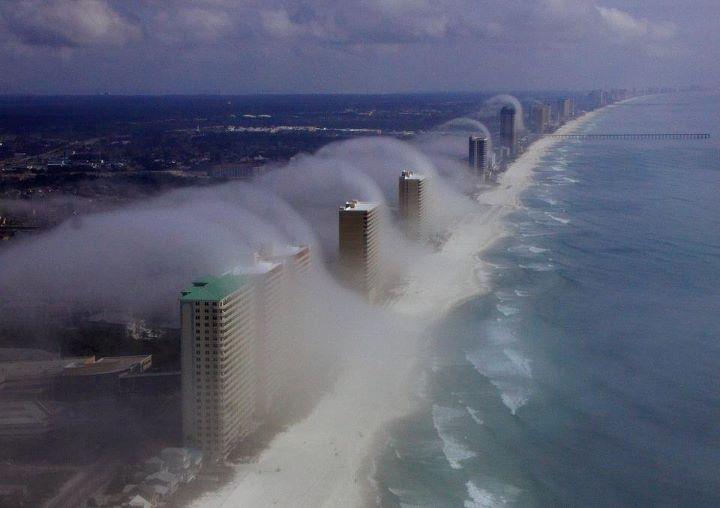
With fog prevalent for the past couple of mornings in northern Illinois, I thought it was only appropriate to show that you are not alone.
The view above is along Panama City Beach, Florida. Yes, even the luxurious beaches in the United States gets fog too. It is actually quite a special circumstance that this fog is occurring. What is happening is that Panama City Beach is experiencing very fluid onshore flow off of the Gulf of Mexico. When this happens, the flow of the air moves towards these high rise buildings and the pressure drops. This, in turn, results in condensation which is seen as fog. The air continues to be pushed up and over the buildings. Then, just like it started, returns near the ground.
If you recall, Wednesday had nothing but sunny skies and mid
50° weather. But like the saying goes, “All good things must come to an end.”
For most of us, we were ecstatic to finally get some measurable snow. The setup
was quite different, in that we banked off another storm for moisture. The low
pressure system that moved up along the East Coast provided sufficient moisture
from the Alberta Clipper system that we received. With our forecast of four to
eight inches, it seemed almost probable that most locations would get the high
end amount from this storm. It was all day Wednesday that we watched as the weather
system from Canada slowly moved through the upper Midwest. By early morning
Thursday, this system entered Illinois. It was not until around 7 AM that snow
reached the western suburbs of Chicago.
Snow continued throughout the entirety of the day into the overnight
hours. And after almost 11 months, it was nice to finally drop the blade.